Shapefile Export Tutorial
Reference:
- Working with the GIS Platform <working_with_the_gis_platform> (Developers Guide)
- http://docs.geotools.org/
Source code:
- Available in your uDig SDK (import the source code <code_examples> from the plugins view)
- plugin: org.locationtech.udig.tutorials.shpexport (github)
Introduction
We are going to use an operation to work with the GeoTools FeatureSource interface. The FeatureSource API allows access to geographic data in the form of simple features: consisting of a geometry along with some attributes. Features of the same kind are said to belong to the same FeatureType (much as java objects are said to belong to the same class.
Here is a comparison between Java Class and Geographic FeatureType:
| Domain | Java | Geographic Rich | Geographic Simple |
| Classification | Class<?> | FeatureType | SimpleFeatureType |
| Instance | Object | Feature | SimpleFeature |
| Data | Field (simple types) | Attribute | Attribute |
| Association | Field (object types) | Association | n/a |
| Messages | Methods | Operation | n/a |
After completing this section, you will have gained the skills to:
- Create a new shapefile (as a FeatureStore)
- Access a FeatureCollection (from a FeatureSource)
- Copy features from a FeatureSource to a FeatureStore
GeoTools and Features
In this section you will implement an operation which will take features from an arbitrary FeatureSource, and copy them into a shapefile FeatureStore.
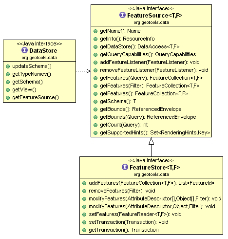
FeatureSource provides read-only methods for accessing geographic data. The subclass FeatureStore provides read-write methods if available. You can check if a file is writable using a simple Java “instance of” check.
String typeNames = dataStore.getTypeNames()[0];
SimpleFeatureSource source = store.getfeatureSource( typeName );
if( source instanceof SimpleFeatureStore){
   SimpleFeatureStore store = (SimpleFeatureStore) source; // write access!
   store.addFeatures( featureCollection );
   store.removeFeatures( filter ); // filter is like SQL WHERE
   store.modifyFeature( attribute, value, filter );
}
When you access the content of a FeatureSource you will get back a FeatureCollection - please be careful and treat this more like a “PrepairedStatement” or “ResultSet”. A FeatureCollection is lazy and offers streamed access to remote content - you must be sure to close any Iterators you open on a FeatureCollection.
SimpleFeatureIterator iterator = featureCollection.features();
    try {
        while( iterator.hasNext() ){
            SimpleFeature feature = iterator.next();
            // process feature
        }
    }
    finally {
        iterator.close();
    }
For more information and examples on the handling of FeatureCollection please check the GeoTools User Guide:
What to Do Next
For better understanding of these facilities please try the following:
Prompt the user for filename
Hint: Look at the existing “promptOverwrite” if you are having trouble opening a FileDialog in the display thread.
Process Features
You now know how to make operations on real data. Can you make your own operation to calculate the entire length for line features? Or the entire area for polygon information?
- Hint: You will need to use the FeatureCollection - remember to close your iterator!
- Hint: Check the GeoTools User Guide mentioned earlier if you are stuck!
Catalog Add
Advanced: Did you find it annoying to hunt down your file after you created it? The Eclipse User Interface Guidelines say that we should make the results of an operation visible after it is performed. Please add your new shapefile to to the local catalog after it has been created.
Bonus points for selecting it in the CatalogView after it is added.
Operation Enablement
The shape file format is limited to handling one geometry type at a time (so Point or LineString or Polygon - not a general Geometry).
To meet the Eclipse House Rules we should not contribute an operation to the user interface when it cannot operate - can you change when the operation is enabled based on the schema information?
Calculated Attribute
Can you write out your shape file with an additional Area (or Length) attribute?
Hint: Working with FeatureType is hard; the FeatureBuilder and DataUtilities class contains methods to help you along.
Filter
Can you write out a shape file with only the features that passes a certain test? ( like cities with POP_RANK > 5 )
The OGC filter specification, or the GeoAPI Filter interfaces, let you write tests in a manner similar to SQL. Can you figure out how to make a Filter?
Hint: The CQL parser will make Filters based on a provided String.
Tips, Tricks and Suggestions
The following tips have been provided by the udig-devel list; please stop by and introduce yourself.
Display Thread
If you check back in the first Tool Plugin Tutorial or IAdaptable and Operations Tutorial tutorial you will find a couple examples of how to open something on the display thread.
Many examples on the internet show how to use the Display class provided by swt. This class can actually be a bit tricky to use.
Jesse has provided a couple of helper methods that capture the best practices around the use of this class (that take care of all the annoying null checks):
PlatformGIS.asyncInDisplayThread( runnable, true ); // if in the display thread it will run right away
There are more helper methods there covering several possible scenarios; including syncInDisplayThread.
Returning a Result from Sync Runnable
There are a couple of ways to return a result from a synchronized runnable (one where your thread pauses while the display thread queues up your Runnable and prompts the user for something):
You can make the Runnable into a inner class; and use a field to store the result you wish to return.
class FilePromptRunnable implements Runnable {
   void String result;
   public void run(){
       result = "Hello World";
   }
   public String getResult(){
       return result;
   }
};
FilePromptRunnable runPrompt = new FilePromptRunnable();
PlatformGIS.asyncInDisplayThread( runPrompt );

System.out.println("File:"+runPrompt.getResult());
You can also cheat by using an array as a Java Pointer; this allows you to make use of an anonymous Runnable:
final static String result[] = new String[1];

PlatformGIS.asyncInDisplayThread( new Runnable(){
    public void run(){
         result[0] = "hello world";
    }
});
System.out.println( "Result:"+result[0] );
A common mistake when writing an operation is to make use of a field. A long running operation may be run more than once at the same time - so it is nice to make sure each Runnable has a chance to return its result independently.
Commercial Training Materials
Please contact any of the organisations listed on the main uDig support page for details on uDig training.
The workbooks and slides for the training course are available here:
This is a private svn repository that is open to those who have taken the training course.
Academic Access
The course materials can be made available to those working at academic institutions - we ask for an email from your Professor.
Please ask your professor to email admin@refractions.net with the request.