GIS Application Tutorials
The GIS Application is used for the core uDig ideas of map, layers and tools.
The following tutorials are available:
Reference:
GIS Application
The GIS Application serves as the basic GIS for your own customisations. It is the second tier of the Platform Architecture:
- Custom Application
- GIS Application
- GIS Platform
The GIS Application is essentially the running uDig application including the GUI.
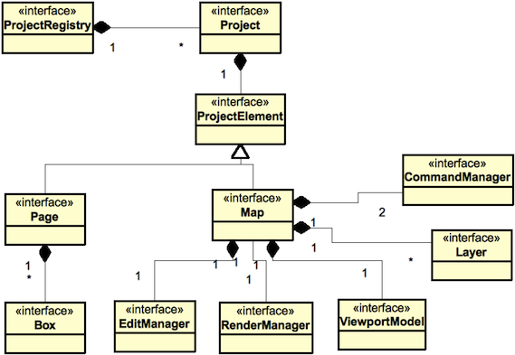
Data Model
GIS Application provides a Project-Map-Layer model which you can see in the user interface:
- Project is shown by the ProjectView with a breakdown of your open projects
- Map is shown by the MapEditor - where it is used render your layers and allows you to zoom and edit features.
- Layer is shown by the LayersView where you can select what layers to render, and order them.
- The actual data from the Layers comes from a GeoResource (like PostGis or a Shape File). The rendering system will use IResolve to access the data as appropriate.
- The Style Editor (and Style view) allow you to change the style of various map features. This information is stored on a “style blackboard” for use by both the style editor and the rendering system.
- A “decorator” is implemented as a MapGraphic (basically a layer without specific data such as a scale bar or legend)
Note
uDig generally uses blackboard for inter component communication; the coordinate tool and coordinate map graphic is an introduction to this idea
Commands
The second bit of fun here is the above data model is not available for you to change directly. In earlier copies of uDig we had the data model available for direct modification so you could call setter methods and the user interface would update.
This resulted in a lot of deadlocks due to these restrictions:
- code that works with any kind of data should not be in the user interface thread (or the application will appear to “freeze up”)
- code that updates the screen or user interface must be in the Display Thread
What we have come up with is the use of Commands:
map.sendCommandASynch( command );
There are a number of commands available in uDig and you can role your own:
NavCommand goHome = new SetViewportCenterCommand(new Coordinate(x,y), DefaultGeographicCRS.WGS84 );
map.sendASyncCommand( goHome );
For more information:
- Commands (Developers Guide)