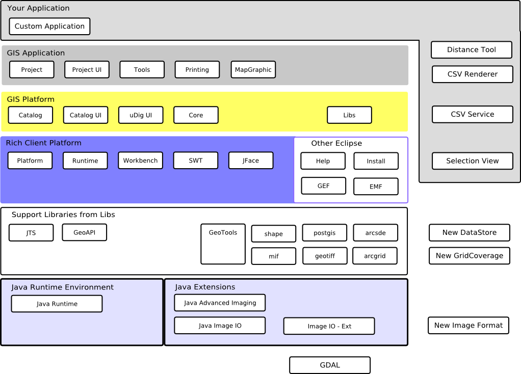
Platform Architecture
The UDIG GISPlatform is built around the concept of plug-ins to the base Eclipse Rich Client Platform. In addition uDig makes use of the several support libraries and a couple extensions to the Java Runtime Environment.
References:
It is useful to consider the UDIG application as a series of Tiers each with different responsibilities and capabilities.
If you are new to Eclipse RCP development it is helpful to go through the tutorials included with Eclipse prior to working with uDig.
GIS Application
Project services opperates as a UDIG application providing Maps and Printing under user control. The GIS Application layer also provides Rendering and Tool services allow control of display and screen interaction.
New Tool
For some quick experience implementing a new tool:
- please extend the SimpleTool class. For more details please review the Distance Tool tutorial.
New Application
For more information on extending the GIS Application for your own use please review:
- the custom application tutorial for a uDig like application
- the source code for the rcp tutorial if you are interested in adding uDig visualization to an existing application
New Renderer
To visualize your own custom data format you will need to implement a custom RenderMetricsFactory. This will allow uDig to render a layer created around your data format.
For more information please review the source code for the CSVRenderer tutorial.
GIS Platform
Catalog Services provide a common API for data access and may serve as foundation for different GIS applications.
New Data Format
To add support for a data format (of any description) you will need to add a new ServiceExtension. This will allow uDig to hold onto the information you wish in the catalog and make it available to other parts of the application.
For more information please review the source code for the CSVService tutorial.
Eclipse Rich Client Platform
We make use of the plug-ins contained in the Eclipse Rich Client platform. These plug-ins provide the base implementation of a workbench window, the runtime platform that is used to wire up the application and so on.
- runtime - contains the Platform and Application extension points
- ui - support for the workbench window, workbench selection and menus
- standard widget toolkit (swt) - direct implementation of user interface widgets
- jface - ease the use of tree and table widgets by introducing adapters between your domain objects and the raw swt widgets
In addition we make use of:
- Help - to provide online help
- Install - access to the update manager
- Eclipse Modeling Framework (EMF) - used to implement the uDig data model of Maps, Layers and ViewportModel
- Graphical Editing Framework (GEF) - used to create a quick visual editor work Page layout
Support Libraries
The support libraries used by uDig are:
- JTS Topology Suite - provides an implementation of the Simple Feature for SQL definition of Geometry (ie Point, Line and Polygon)
- GeoAPI - provides common java interfaces for geospatial concepts based on OGC standards
- GeoTools - a grab back of geospatial know-how, including an implementation of the interfaces defined by GeoAPI
These libraries provide useful abstractions (such as Geometry and Feature) and data connectivity. These libraries are all gathered into a single plug-in (org.locationtech.udig.libs plugin) so they may share a classloader.
Currently the GeoTools library makes use of a plug-in system called “factory spi” that depends on plugins being available in the same classloader as the core library. This is a limitation we would like to see lifted in the future.
New GridCoverage (Geospatial Raster Format)
To add support for a new GridCoverage format (ie geospatial raster) you will need to write a new plug-in for GeoTools that implements the GridCovreageReader interface. If you implement this interface you will be able to leverage the existing uDig image rendering system.
For more information please review the GeoTools user guide, source code and test cases.
New DataStore (Geospatial Vector Format)
To add support for a new Vector format you will need to implement a new GeoTools plugin that implements the DataAccess (for rich content) or DataStore (for simple content) interface. If you implement either of these interfaces you will be able to make use of the existing uDig rendering system and Style Layer Descriptor support.
For more information please review the GeoTools user guide, source code and test cases.
Java Runtime Environment
The uDig application makes use of JRE version 5.0 at this time (although some platforms are making use of Java 6 we are limiting adoption until Java 6 is available on all platforms).
We also make use of two important extensions to the default JRE install:
- Java Advanced Imaging - performs image processing tasks; defined as a series of operations on raw raster formats
- Java Image IO - provides raw raster format implementations (Java includes PNG, JPEG etc out of the box)
- ImageIO-EXT - additional geospatial raster formats such as GeoTIFF and MRSID
New Image Format
To add support for a new Image Format please consider extending the Java Image IO project. You will find some GeoTools Alumni have started an ImageIO-EXT project in order to teach ImageIO about common geospatial formats. The ImageIO-EXT project has made use of GDAL SWIG bindings in order to leverage C++ support for some of the more exotic formats.
For more information please visit the ImageIO-EXT website.