Documents
Documents provide support information for resources and features. These come in the form of attachments, links and hotlinks.
The Document View provides a user interface to access and manage these documents. It is driven by an API that allows developers to customise the document data models and the document sources. This provides the flexibility of implementing your own document classes and publishing them to the view.
These facilities are also used to allow an IGeoResource to publish support files (such as default style or icon sets).
Document
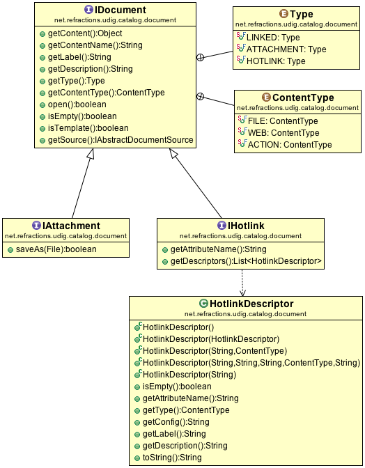
IDocument Classes
These are the data models that we can implement to define a document.
- IDocument - The basic document data model. This provides access to the document’s content and other metadata like label and description.
- IAttachment - An add-on to IDocument. This provides the attachment specific Save As method.
- IHotlink - An add-on to IDocument. This provides access to hotlink metadata including the attribute name used to record the file or web link. The list of descriptors captures how the hotlink is to be used, especially for attribtues that are configured with several actions.
Documents Sources
These are the document sources that we can implement to provide access to documents and allow getting, adding, updating and deleting of documents.
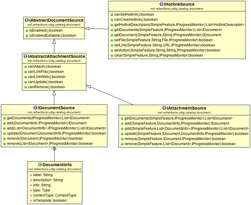
These make use of the data models above to communicate to and from the Document View.
IDocumentSource
IDocumentSource provides access to resource-level attachments and links.
Example Implementation ShpDocumentSource copies attachments into a folder and records the DocumentInfo information in the property file.
To access a list of documents:
IDocumentSource documents = geoResource.resolve( IDocumentSource.class, new NullProgressMonitor );
List<IDocument> list = documents.getDocuments( new NullProgressMonitor() );
To register a support file (such as a default style) with a GeoResource:
IDocumentSource documents = geoResource.resolve( IDocumentSource.class, new NullProgressMonitor );

DocumentInfo docInfo = new DocumentInfo("default.sld", "Default style", file.getAbsolutePath(), ContentType.FILE, false, Type.ATTACHMENT);
documents.add(docInfo, new NullProgressMonitor() );
IAttachmentSource
IAttachmentSource provides access to feature-level attachments and link.
Example Implementation ShpAttachmentSource copies attachments into a folder and records the DocumentInfo metadata in a property file.
To list attachments for a feature:
IAttachmentSource attachments = geoResource.resolve( IAttachmentSource.class, new NullProgressMonitor );
List<IDocument> list = attachments.getDocuments(feature, monitor);
To add an attachment, such as an image, to a feature:
IDocumentSource documents = geoResource.resolve( IDocumentSource.class, new NullProgressMonitor );

DocumentInfo docInfo = new DocumentInfo("picture.jpg", "Location picture", file.getAbsolutePath(), ContentType.FILE, false, Type.ATTACHMENT);
documents.add(feature, docInfo, new NullProgressMonitor() );
IHotlinkSource
Provides access to feature hotlinks. IHotlinkSource is interesting in that it is used to update the value of a feature, which you then need to commit in the usual manner.
Example Implementation: org.locationtech.udig.document.source.ShpHotlinkSource
To list hotlinks for a feature:
IHotlinkSource hotlinks = geoResource.resolve( IHotlinkSource.class, new NullProgressMonitor );

List<HotlinkDescriptor> descriptors = hotlinks.getHotlinkDescriptors( feature, new NullProgressMonitor() );
List<IDocument> list = hotlinks.getDocuments(feature, monitor);
To update a hotlink attribute:
hotlinks.setFile( feature, hotlinkDescriptor.getAttributeName(), file, new IProgressMonitor() );
Object value = feature.getProperty( hotlinkDescriptor.getAttributeName() );
Filter filter = ff.id( feature.getIdentifier() );
featureStore.modifyFeatures( filter, hotlinkDescriptor.getAttributeName(), value );
Integration with Document View
The Document View listens to the workbench selection and checks if it can get any of the document source classes from the current IGeoResource selections.
How the view gets a document source:
final IGeoResource geoResource = // Get from selection
final Class<T> type = // IDocumentSource.class, IAttachmentSource.class or IHotlinkSource.class

if (geoResource != null) {
   if (geoResource.canResolve(type)) {
      try {
         return geoResource.resolve(type, monitor);
      } catch (IOException e) {
         e.printStackTrace();
      }
   }
}
return null;
To integrate with Document view make sure your selection resolves to an IGeoResource, and configure the IGeoResource to resolve to one of the document source interfaces.
Configure Generic Hotlink Support
Generic hotlink support is available for any FeatureSource hosted by the uDig catalog.
The IGeoResource persisted properties are used to store metadata marking attributes to be used for hotlink storage.
You can turn this on yourself as a developer using the following:
BasicHotlinkDescriptorParser configure = new BasicHotlinkDescriptorParser( geoResource );

configure.setEnabled( true );
List<HotlinkDescriptor> descriptors = new ArrayList<HotlinkDescriptor>();
descriptors.add( new HotlinkDescriptor("report", ContentType.FILE ) );
descriptors.add( new HotlinkDescriptor("citation", ContentType.WEB ) );

configure.setDescriptors( descriptors );
Configure Shapefile Documents
Here is an example properties file:
#
#Thu Sep 13 10:32:49 EST 2012
shp_documents_enabled=true
australia.8_documents=http\://au.yahoo.com|~|LINKED|~|WEB|~|Yahoo Website|~|Sample website link.|~|false|\:|\
                      australia.documents/australia.8/template.dot|~|ATTACHMENT|~|FILE|~|Sample template|~|A template attachment|~|true|\:|\
                      australia.documents/australia.8/readme.txt|~|ATTACHMENT|~|FILE|~|ReadMe file|~|Sample file attachment|~|false
feature_documents_enabled=true
shp_documents=australia.documents/act-info.txt|~|ATTACHMENT|~|FILE|~|State Information|~|Information about the state|~|false|\:|\
              australia.documents/New File.doc|~|ATTACHMENT|~|FILE|~|Document attachment|~|Another attachment|~|false|\:|\
              http\://sports.yahoo.com/nba|~|LINKED|~|WEB|~|Sports Website|~|New website|~|false
Configure Custom Documents
When working on your own data type or custom application you can add document support to any existing IGeoResource.
Example: tie a database table to a content management system.
How to hook up a document source:
- Implement the document sources, see sample implementations above
- If you have your own custom IGeoResource class you can update the IResolve methods canReoslve and resolve.
- If you are working with a provided IGeoResource class you can use the the org.locationtech.udig.catalog.resolvers extension point
<extension
      id="shp"
      name="Shapefile Document Resolvers"
      point="org.locationtech.udig.catalog.resolvers">
   <factory
         class="org.locationtech.udig.document.source.ShpDocumentResolveFactory"
         resolveableType="org.locationtech.udig.catalog.internal.shp.ShpGeoResourceImpl">
      <resolve
            type="org.locationtech.udig.catalog.document.IHotlinkSource"></resolve>
      <resolve
            type="org.locationtech.udig.catalog.document.IDocumentSource"></resolve>
      <resolve
            type="org.locationtech.udig.catalog.document.IAttachmentSource">
      </resolve>
   </factory>
</extension>
- Implement the IResolveAdapterFactory referenced by the extension and integrate the document sources
public class ShpDocumentResolveFactory implements IResolveAdapterFactory {

 @Override
 public boolean canAdapt(IResolve resolve, Class<?> adapter) {
     if (resolve instanceof ShpGeoResourceImpl) {
         if (adapter.isAssignableFrom(IDocumentSource.class)
                 || adapter.isAssignableFrom(IHotlinkSource.class)
                 || adapter.isAssignableFrom(IAttachmentSource.class)) {
             return true;
         }
     }
     return false;
 }

 @Override
 public <T> T adapt(IResolve resolve, Class<T> adapter, IProgressMonitor monitor)
         throws IOException {

     if (resolve instanceof ShpGeoResourceImpl) {
         final ShpGeoResourceImpl shpGeoResource = (ShpGeoResourceImpl) resolve;
         if (adapter.isAssignableFrom(IDocumentSource.class)) {
             IDocumentSource documentSource = new ShpDocumentSource(shpGeoResource);
             if (documentSource != null) {
                 return adapter.cast(documentSource);
             }
         }
         if (adapter.isAssignableFrom(IHotlinkSource.class)) {
             IHotlinkSource hotlink = new ShpHotlinkSource(shpGeoResource);
             if (hotlink != null) {
                 return adapter.cast(hotlink);
             }
         }
         if (adapter.isAssignableFrom(IAttachmentSource.class)) {
             IAttachmentSource attachmentSource = new ShpAttachmentSource(shpGeoResource);
             if (attachmentSource != null) {
                 return adapter.cast(attachmentSource);
             }
         }
     }

     return null;
 }

}